

High Impact Winter Storm Friday into Saturday Get Ready!
- Dec 21, 2017
- 1 min read
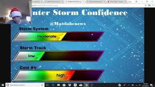
It's coming, get ready! A mix of rain, snow, and freezing rain! Snow starts tomorrow morning and last through the evening up until 8pm. Then, a change to freezing rain inland which will last into the day Saturday and will likely see the heaviest precipitation amounts fall during the day Saturday. The biggest issue will be the freezing rain threat. There is the potential for a ice storm which would mean greater than 0.25'' ice accumulation. If freezing rain amounts can exceed a quarter of an inch there is the potential for power outages. Travel will be dangerous. Outside of the freezing rain zone, it will be a cold rain with temps in the 40s.
Here are my forecast.


Comments