

Winter Storm Threat Friday and Monday
- Dec 20, 2017
- 1 min read
Looking at the model guidance for Friday and Monday, there is the potential for high impact winter storms.
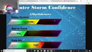
First, let's start with the Friday into Saturday storm setup. A storm will be coming out of the west during the day Friday and start bringing wintry precip to the area by Friday afternoon and evening. By Friday night, wintry precip is falling across the area. With strong high pressure off to the northeast, and cool temperatures at the surface, there is the potential for wintry precip and possibly freezing rain depending on the amount of warm air aloft. It is a hard thing to forecast how the layer in the atmosphere will setup but the potential for a ice storm is possible for interior Southern New England Friday into Saturday before changing to rain Saturday afternoon if the cold air at the surface is eroded away which models do struggle with by the way. I will have another post about the Monday storm later on as guidance gets more consistent. Stay tuned! Here is one model solution for the Friday into Saturday storm.


Comments