

Evening Update
- Dec 21, 2017
- 1 min read
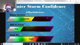
Not much has changed since this morning with the overall setup of the winter storm and the timing. The only thing that has changed is the further southward extent of freezing rain into Rhode Island. I think this is high impact event with the freezing rain being the biggest issue during the day Saturday. There is still some question as to when or if the changeover to rain will occur inland and how much precip will actually fall over the area subject to freezing rain. If you live in the Merrimack Valley into the Worcester Hills and Southwest into the Connecticut River Valley, be prepared for the potential power loss.
Here is my updated ice accumulation forecast. Hope I'm wrong.


Comments