

Long Term Pattern Change in Store
- Dec 4, 2017
- 2 min read
As many of you have probably heard, temperatures will dramatically drop in the eastern US in the next few days, and look to stay on the cold side in the near future.

Currently, the front that is supposed to bring this long term change has pushed through the plains, and into the Midwest region. It will continue to strengthen and push eastward, and reach the east coast in the early hours of December 6th.
The precipitation associated with this front will most likely be rain, except for some snow showers on the back of it. However, we could looking at some heavy rain associated with this, and could accumulate up to a few inches in a few locations.

After this front pushes through, warm weather could start to build into the west. The eastern US will be cold, but relatively dry for around a week, and the only snow potential for the region will come from Alberta Clippers.

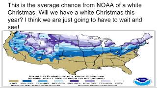
(Graphic created by USA Today)
After the first week of this pattern, models are showing lots of potential for snow in the Midwest, Northeast, and Mid Atlantic, though we are uncertain about where, when, and how much snow could fall, because we are pretty far out still.

What you should take away from this is that a big pattern change is in store for the US, with warmer temperatures in the western and central US, and colder temperatures in the eastern US. Snow potential in the eastern US looks to increase and we go though December, and Alberta Clippers are most likely to be the snow producers.
I, as well as all the members of USWC, will keep you updated on the weather ahead, so make sure to keeping coming back to see what weather is in store for you!


Comments