

Upcoming Cooler Pattern in December?
- Nov 26, 2017
- 3 min read
Hi everyone! This is my first blog post for USWC. I've been a member since October, but haven't had the chance to blog here. Thank you to the founders of USWC for this opportunity!
Well, let's get straight into it.
This November has been somewhat cold for the eastern half of the nation. The beginning of the month included a few record highs, and the middle of the month included record lows. There is a little bit of a cycle in the patterns of the earth. It gets warmer, then colder, warmer, then colder. Well now since we had the colder part of the cycle, it's time for a small warmup. Not that warm, though. Sorry!
To end the month, for the majority of the northeastern United States, temperatures will climb into the 50s, and in some cases, the low 60s. According to many models, that pattern will continue into the early part of December. Most models also hint at a much cooler pattern for the central and eastern part of the nation as we get past December 7th.

Above is the midday guidance (11/26/17) from the Global Forecast System model, or GFS for short. This particular map shows the model's depiction of the temperatures compared to normal. As you can see, the colder than normal air (blue) slides into the region as we get into the second week of December.
Although models should never be solely reliant on, they do give us a clue to what's ahead. Since other models like the ECMWF (European model) and CMC (Canadian model) also agree on this cold shot, it gives us some reasoning for counting on this to verify.
The reason for this cold air is the negative NAO. NAO stands for North Atlantic Oscillation. When there is a negative NAO, there is blocking in the North Atlantic, mainly near or on top of Greenland. This blocking can cause traffic in the Atlantic, which can cause storms to move through at a slower speed. If there is blocking in Greenland, the cold air (traveling with a trough) is forced south; right into the eastern half of the United States. Because of this, the western half usually receives a ridge, or a dome of "warmer" air.
In the next few weeks, there has also been a signal of much more frequent storms over the northern Pacific Ocean along with Siberia and Alaska. Now you may ask; "what does this have to do with the United States?". Well, most of the storms that develop over the Pacific transfer their energy to North America, and impact our weather here.

As you can see in this model depiction, there is a lot going on. All of the "L"s on the map indicate areas of low pressure. In the North Pacific, there will be many developing, and rather strong at that. Most, if not all, of those storms will make their way into Canada and eventually the US.
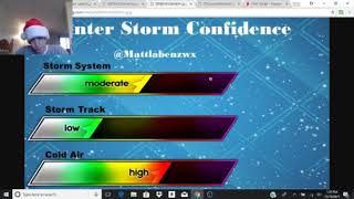
If there is traffic in the North Atlantic, cold air in the eastern half of the US, and frequent storms moving from the north and west, we could be looking at an interesting second and third week of December. Our own Matthew Labenz wrote on Twitter;
Matthew Labenz❄️ @MattLabenzwx 12:34 PM - 26 Nov 2017
"Latest GEFS still has very cold and stormy pattern as we head towards Dec. 8th and onward. Now waiting for EPS data but signal here is COLD. #winteriscoming"
I don't want to go into any specifics of what we might in terms of snow/rain/mix etc. yet, it is way too early. But, since we will have a trough in the eastern part of the country, a coastal storm or two will not be out of the question!
This pattern may linger through the holidays, so stay tuned to USWC for more blog updates by our team as we will be watching this pattern very closely. If you have any questions, just tweet one of our members and we will be happy to answer your question(s)!


Comments