

Potential Winter Storm
- Dec 8, 2017
- 1 min read
Since last week we've been watching a potential coastal storm for Friday. However yesterday's model guidance pushed the threat later in to Saturday and early Sunday. Also models were struggling on the placement of the upcoming trough. Here is the NAM forecast for

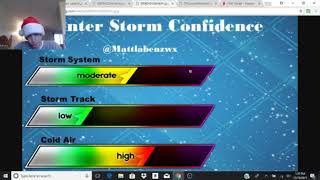
Key for a winter storm is at least a neutral trough even better a negative tilt in the trough. Looking at today's 12Z Model guidance things shifted west to northwest and got very interesting. The GFS/CMC/ECMWF and the NAM and some other models all shifted west bringing the mid-atlantic/northeast coast back in to the game giving the mid-atlantic/northeast a good 3-6" and even 6-8." Because the ocean temps across the eastern seaboard are well above freezing we'll likely see mixing issues along and south of the I-95 corridor. Here is my precipitation forecast.

I do have wintry mix for southeastern mass due to warmer waters.. because of this I think about an less than an inch in eastern Cape Cod. And higher amounts NW of Cape Cod.

Possible banding may set up. If any it wouldn't be a strong classic banding just heavier bands.
If the storm continues to trend NW Mixing line may inch further NW. If it trends SE or remains where it is we are likely gonna see this much of snow. NWS Has issued a Winter Weather Advisory for much of Southern New England. Stay tuned to our Watches/Warnings page for automatic updates! We can all enjoy this little yet impressive storm and it's just the start of what could be a sleepless winter!
Forecaster: Matthew Ferreira


Comments